


African Union Challenges Centuries-Old Cartographic Bias, Calling for Abandonment of the Mercator Projection
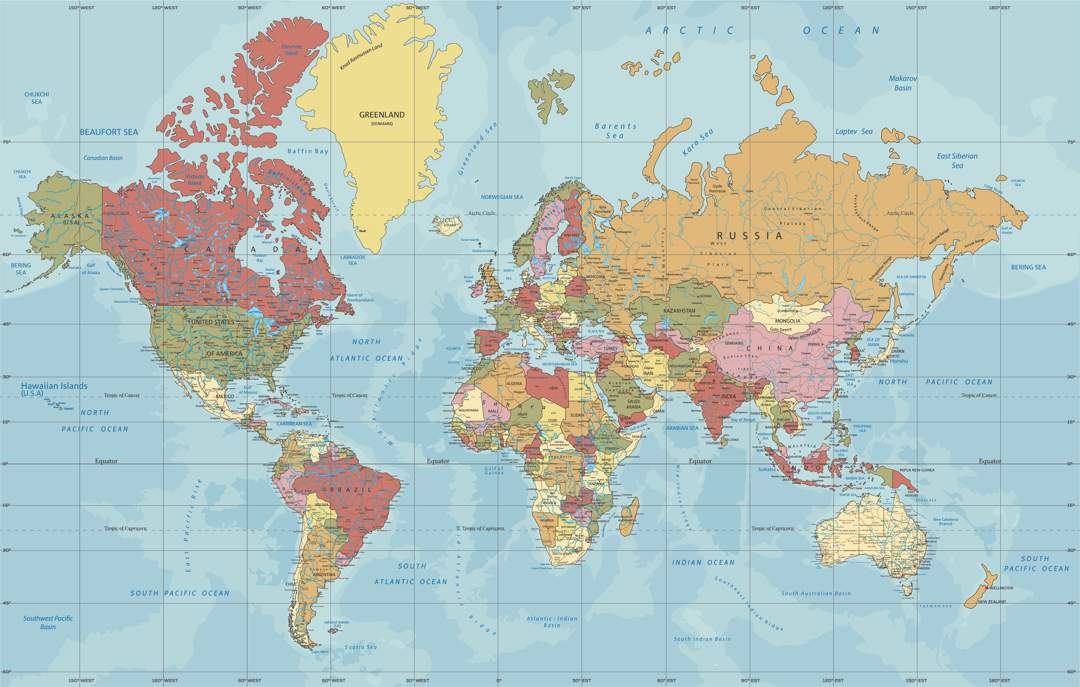
The familiar world map adorning classroom walls worldwide, known as the Mercator projection, faces a growing challenge from the African Union (AU), which has endorsed a campaign to replace it with a more accurate representation of the continent’s size. The AU argues that the Mercator map, created in the 16th century, perpetuates misinformation by significantly shrinking the depiction of Africa and South America while exaggerating the size of Europe and North America. This distortion, the AU contends, reinforces a false perception of Africa as marginal, despite it being the second-largest continent, both in landmass and population, with over a billion people.
The Mercator projection, designed during the age of European maritime navigation, has long been criticized for its Eurocentric bias. Though representing a spherical globe on a flat surface presents inherent challenges, critics argue the Mercator projection’s distortions go beyond mere technical limitations. The AU’s deputy chairperson, Selma Malika Haddadi, emphasized that the map’s implications extend beyond mere cartography, stating that it fosters a skewed understanding of global geography and perpetuates historical biases. Advocacy groups, including Africa No Filter and Speak Up Africa, have reignited the debate, highlighting the map’s detrimental impact on African identity and pride, particularly among school children exposed to this distorted representation from an early age.
The campaign to “Correct the Map” has gained significant traction, with the AU actively advocating for the adoption of alternative projections, such as the Equal Earth projection, which aims for a more balanced representation of landmasses. The Equal Earth projection maintains the familiar rectangular shape while more accurately depicting the relative sizes of continents. This movement has spurred discussions about incorporating the Equal Earth projection into educational curricula across Africa and encouraging its use by global institutions. Moky Makura, executive director of Africa No Filter, described the Mercator projection as “the world’s longest misinformation and disinformation campaign,” calling for its immediate discontinuation.
The AU plans to collaborate with member states to promote wider adoption of alternative map projections and discuss collective actions to rectify the historical cartographic inaccuracies. This push for change reflects a broader movement to decolonize knowledge and challenge Eurocentric perspectives embedded in various fields, including education and representation. The AU’s initiative seeks to ensure that future generations have access to a more accurate and balanced understanding of global geography, free from the biases inherited from colonial times.
The petition driving the “Correct the Map” campaign has garnered widespread support, nearing its goal of 5,000 signatures. The campaign organizers believe that correcting the map of Africa will significantly impact perceptions of the continent, highlighting its true scale, power, and potential. By challenging the dominance of the Mercator projection, the AU and its allies aim to dismantle a persistent symbol of colonial bias and empower a more accurate and equitable representation of the world.
The implications of this cartographic shift extend beyond mere symbolism. By correcting the visual representation of Africa, the AU hopes to foster a more accurate understanding of the continent’s role in global affairs. This initiative aligns with broader efforts to promote African agency and challenge historical narratives that have marginalized the continent. The AU’s challenge to the Mercator projection signifies a crucial step towards decolonizing knowledge and building a more equitable and representative world view. The debate surrounding the Mercator projection underscores the power of maps not just as tools of navigation but also as instruments that shape our understanding of the world and its diverse inhabitants.


